
Emergency response has one currency that matters more than any other: seconds. A dispatcher who takes twenty extra seconds to confirm an address, or a system that can't tell an available unit from a busy one, doesn't just slow down a workflow — it changes outcomes on the ground.
For decades, dispatch ran on phone lines, radio chatter, and whiteboards. That approach worked when call volumes were low and communication channels were simple. It doesn't hold up anymore. Agencies now field emergency texts, video calls, IoT alerts, and multi-channel reports, often during the same shift. A modern computer aided dispatch system has to do more than log calls and assign units — it has to manage the entire incident lifecycle, from the first ring to the closed case file.
Based on years of watching emergency technology evolve, one pattern keeps showing up: agencies rarely fail because they lack data. They fail because they can't turn incoming information into action fast enough. A well-built CAD platform closes that gap. It takes fragmented information — a caller's voice, a GPS ping, a unit's status — and turns it into a coordinated response decision in seconds rather than minutes.
What is a Computer Aided Dispatch System?
A Computer Aided Dispatch System is an emergency management platform that helps dispatchers receive calls, identify incidents, assign resources, track field units, communicate with responders, and maintain complete incident records through a centralized digital workflow.
Why Computer Aided Dispatch Systems Are Critical in Modern Emergency Operations
Call volumes keep climbing, and they're not climbing in a straight line — spikes now come from social media-driven incidents, extreme weather events, and public gatherings that didn't exist as risk factors a decade ago. On top of that, callers no longer just dial a number. They text, they send photos, they use apps that route straight into 911 centers. A system built only for voice calls is already behind.
This is why agencies are investing in advanced dispatch automation and emergency response technology rather than patching together legacy tools. The demands have shifted:
- Higher and less predictable emergency call volumes
- More digital communication channels feeding into one center
- Pressure to shorten response times, not just track them
- Multi-agency coordination that has to happen in real time, not after the fact
- Leadership asking for operational visibility they can actually see on a screen
A capable public safety software platform supports every branch of emergency response — police units coordinating a pursuit, fire crews responding to a structure fire, EMS teams managing a mass-casualty event, disaster response teams working a flood zone, and government emergency operations centers running it all from one command view. The common thread across all of them is the same emergency communication platform doing the coordinating work in the background.
15 Features Every Computer Aided Dispatch System Should Include
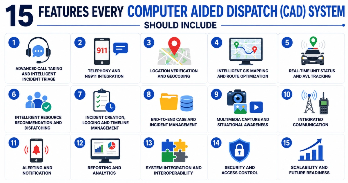
Here's the part that matters most if you're evaluating or upgrading a CAD platform. These are the fifteen capabilities that separate a genuinely modern system from one that's just digitized the old way of doing things.
1. Advanced Call Taking and Intelligent Incident Triage
Call handling is the foundation everything else sits on. If the intake process is slow or error-prone, nothing downstream fixes it. Strong computer aided dispatch system features start here, with:
- Automated capture of incoming emergency calls
- Structured questioning workflows that guide dispatchers through the right questions in the right order
- Automatic incident classification based on caller input
- Priority assignment that doesn't rely purely on dispatcher judgment under stress
- On-screen guidance that keeps less experienced dispatchers on script during high-pressure calls
The payoff is straightforward: fewer manual entry errors, more complete caller information, and faster decisions in the first ninety seconds of a call — usually the ones that matter most.
2. Telephony and NG911 Integration
Voice-only dispatch is a thing of the past. Callers now reach out through text-to-911, multimedia messages, photos, and videos, and agencies need one screen that handles all of it — not five separate systems duct-taped together.
Key emergency dispatch software features in this category include:
- Standard voice call handling
- Text-to-911 support
- Multimedia message intake (photos, videos, files)
- Automatic call recording
- ANI/ALI integration for caller identification and location
A unified communication interface means a dispatcher isn't toggling between four windows while someone is describing an emergency in real time. That alone reduces the risk of missed or misheard details.
3. Location Verification and Geocoding
Location errors cost time, and time is the one resource dispatch can't create more of. Callers under stress give wrong cross-streets. Mobile callers don't know exactly where they are. Landmarks get described instead of addresses.
Location intelligence features address this directly:
- Automatic address validation against known databases
- Caller location detection pulled from device or carrier data
- Landmark identification for callers who can't give a precise address
- Jurisdiction verification so the right agency gets the call
Get this wrong and everything downstream — routing, resource allocation, response accuracy — inherits the error.
4. Intelligent GIS Mapping and Route Optimization
Mapping used to be a nice-to-have. Now it's the visual backbone of the entire dispatch operation. Dispatchers need to see incidents, traffic conditions, jurisdiction boundaries, and unit positions on one live map, not reconstruct the picture from memory and radio calls.
This is also where AI in emergency dispatch systems earns its keep. AI-assisted mapping tools go beyond static routes:
- Interactive GIS dashboards showing live incident locations
- Real-time traffic overlays
- Jurisdiction boundary visibility
- Route optimization based on current road conditions
- Predictive ETA calculations that adjust as traffic changes
A dispatcher who can see the fastest available route — not just the shortest one on paper — sends units that actually arrive faster.
5. Real-Time Unit Status and AVL Tracking
Automatic Vehicle Location (AVL) tracking answers a question dispatchers used to have to ask over the radio: where is everyone, right now? Modern systems track vehicle positions and mobile responder locations continuously, with clear status indicators:
- Available
- En route
- Arrived
- Busy
- Clearing
The benefit isn't just convenience. It's faster dispatch decisions, better resource utilization across a shift, and a lot less radio traffic clogging the channel during a busy period.
6. Intelligent Resource Recommendation and Dispatching
Traditional CAD put the entire burden of unit selection on the dispatcher — memory, instinct, and a status board. Modern systems shift that model. Instead of a dispatcher scanning a list under time pressure, the system recommends the optimal resource based on:
- Distance to the incident
- Skill-based matching (a hazmat call needs a hazmat-trained unit, not just the nearest one)
- Equipment availability
- Multi-agency dispatch requirements when an incident crosses jurisdictions
This is one of the clearest examples of AI in emergency dispatch systems moving from a buzzword to a working feature. It doesn't replace dispatcher judgment — it narrows the decision so the dispatcher isn't starting from zero every time.
7. Incident Creation, Logging and Timeline Management
Every action taken during an incident needs a timestamp and a record, whether that's for legal review, internal audit, or an after-action report six months later. Strong logging covers:
- Incident creation and initial classification
- Priority changes as new information comes in
- Every timestamp tied to a dispatcher action
- Full communication history attached to the incident
This isn't paperwork for its own sake. It's the record that protects agencies during legal proceedings, supports investigations, and gives supervisors something concrete to review when they're looking for ways to improve operations.
8. End-to-End Case and Incident Management
An incident doesn't end when the last unit clears the scene. It needs to move through a full lifecycle — opening, updates, linked events, dispatcher notes, and formal closure — and that lifecycle needs to connect to whatever comes next.
That means tight integration with:
- Records Management Systems (RMS)
- Investigation platforms
- Reporting systems used by command staff
Without that connection, agencies end up re-keying the same information into a second system, which is exactly the kind of inefficiency modern CAD is supposed to eliminate.
9. Multimedia Capture and Situational Awareness
Field intelligence isn't limited to what a dispatcher hears over the radio anymore. CCTV feeds, body camera streams, drone footage, and field-submitted images all feed into situational awareness now, and a CAD system that can't ingest them is working with half the picture.
Support for multimedia typically includes:
- CCTV integration
- Body camera feed access
- Drone information feeds
- Field images submitted by responders
- Supporting documents attached directly to the incident
The result is better decision-making in the moment, clearer visibility for supervisors watching an incident unfold, and a more complete incident record once it's over.
10. Records Management and System Integration
Disconnected systems are one of the most common — and most fixable — sources of inefficiency in emergency operations. When CAD, RMS, and reporting tools don't talk to each other, dispatchers and records staff end up doing the same data entry twice.
Look for:
- Open API integration
- Automated data exchange between systems
- Automated reporting pulled directly from incident data
- Reduced duplicate data entry across platforms
Agencies weighing Computer Aided Dispatch Software Solutions should treat integration capability as a first-round filter, not an afterthought — it's the difference between a system that fits into existing infrastructure and one that requires rebuilding it.
11. Analytics, Dashboards and Performance Reporting
Dispatch data is only useful if leadership can actually see what it's telling them. Modern CAD platforms turn raw incident logs into dashboards that inform real decisions:
- Average response time by unit, shift, or district
- Call volume trends over time
- Unit utilization rates
- Peak emergency periods by day, hour, or season
- Overall dispatch efficiency metrics
These numbers shape staffing decisions, budgeting conversations, and performance improvement plans. Without them, leadership is making resourcing calls based on gut feeling instead of evidence.
12. Multi-Agency and Multi-Jurisdiction Support
Large-scale emergencies rarely respect organizational boundaries. A natural disaster, a major public event, or a regional incident pulls in police, fire, and EMS at once — sometimes across multiple counties or even states.
Multi-agency support features include:
- Coordinated police-fire-EMS dispatch
- Mutual aid request handling
- Shared incident visibility across agencies
- Role-based access so each agency sees what it needs, and nothing it shouldn't
When these features work well, agencies stop operating as isolated units during a joint response and start functioning as one coordinated system.
13. Dispatcher-Friendly UX and Productivity Features
In emergency operations, usability isn't a design preference — it directly affects response effectiveness. A cluttered interface that takes seven clicks to dispatch a unit is a liability, not just an inconvenience.
Look for:
- Customizable dashboards tailored to each dispatcher's workflow
- Keyboard shortcuts for high-frequency actions
- Minimal clicks required for common tasks
- Clear, unmistakable alerts for priority incidents
- Workflow customization by role or shift
Good UX shortens training time for new hires, reduces cognitive load during high-stress calls, and speeds up decision-making when speed is the entire point.
14. Scalability, Reliability and Disaster Recovery
Downtime in a CAD system isn't an inconvenience — it's a public safety risk. A platform needs to keep running, or fail gracefully, no matter what's happening outside the building. This is one of the defining modern CAD system features agencies can't compromise on.
Core requirements include:
- Cloud scalability to handle demand spikes
- High availability architecture
- Automated backup systems
- Formal disaster recovery planning
- Offline operation capability when connectivity drops
An agency evaluating vendors should ask directly: what happens to dispatch operations if the primary data center goes down mid-shift? The answer separates enterprise-grade platforms from the rest.
15. Security, Compliance and Audit Capabilities
CAD systems hold sensitive data — caller information, incident details, sometimes medical history relayed during a call. That makes security non-negotiable, particularly for:
- Government agencies subject to strict data handling rules
- Healthcare-adjacent emergency services
- Public safety organizations operating under public records laws
Baseline security features should include:
- End-to-end encryption
- Role-based permissions
- Multi-factor authentication
- Detailed audit logs
- Formal data protection policies
These aren't check-the-box features. They're what stands between an agency and a data breach that ends up in the news.
CAD Software Selection Checklist for Emergency Organizations
If you're comparing vendors, run every option through this checklist for choosing CAD software before signing anything:
- ✓ Does it support NG911 communication, including text and multimedia?
- ✓ Does it provide real-time GIS mapping with route optimization?
- ✓ Does it integrate cleanly with RMS and your existing systems?
- ✓ Does it support AI-powered dispatch recommendations?
- ✓ Can it scale as call volume and staffing grow?
- ✓ Does it meet current security and compliance standards?
- ✓ Is the interface actually built around dispatcher efficiency, or just around a sales demo?
Agencies working through this process in more depth should read our full guide on choosing the best Computer Aided Dispatch Software, which walks through vendor evaluation criteria in more detail.
How AI and Automation Are Transforming CAD Technology
A few trends are shaping where CAD technology is heading through 2026 and beyond:
AI-based dispatch assistance. Predictive response recommendations, automated incident classification, and priority detection are moving from experimental features to standard ones. See AI in emergency dispatch systems for a closer look at how this is playing out across agencies right now.
IoT integration. Smart vehicles, wearable devices, and connected sensors are starting to feed data directly into CAD platforms — a responder's wearable can now flag vitals during a high-risk call before they even radio in.
Cloud-based CAD platforms. Remote accessibility, easier scaling, and lower infrastructure costs are pushing more agencies toward cloud deployment, particularly smaller departments that can't justify a full on-premise data center.
Predictive analytics. Agencies are starting to use historical incident data to forecast emergency patterns and plan staffing and resource allocation ahead of demand, rather than reacting to it after the fact.
Selecting the Right CAD Platform for Future Emergency Operations
CAD systems have moved well past their original job of logging calls and assigning units. They're now strategic emergency management platforms that shape how fast an agency can act and how well it can prove, afterward, that it acted correctly.
When evaluating options, weigh reliability, intelligence, integration capability, and scalability together — not one at the expense of the others. A system with brilliant AI dispatch recommendations that can't integrate with your RMS is still a bottleneck. A rock-solid, secure platform with a clunky interface still slows dispatchers down when it matters most.
The right CAD solution improves dispatcher efficiency, strengthens responder coordination, and — ultimately — improves outcomes for the public these systems exist to protect.
Organizations looking to modernize emergency operations should evaluate Computer Aided Dispatch Software Solutions that combine automation, AI, GIS intelligence, and secure integrations into one platform, rather than assembling one from disconnected tools.